Use the DeLorme Virginia Atlas & Gazetteer
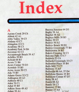
 In the very front of the Virginia Atlas & Gazetteer is the Index. It lists populated places (places where people live), and indicates where you can find that place on a particular map in the atlas. Next to the names of each place are the map number and the grid coordinates on the map.
For example, there's a place in Virginia called Hurt. The GMU-TV crew discovered they were in a "world of Hurt" when taping a program on moonshine in Virginia.
In my edition of the atlas, Hurt is on Map 44, in the grid D1. Turn to map 44 and notice at the top that the columns are numbered 1-7, while on the side of each page the rows are marked by letters A-D. If you're computer-savvy, think of each map as a spreadsheet. Find the "cell" where Column 1 intersects Row D to locate Hurt - just south of Altavista.
In the Index, you will find Richmond, Norfolk, Staunton, and the other cities of the state, big and small. You'll find towns like Amelia Court House and Warrenton. You'll find a place called Retreat and a different place called Return - maybe they changed their mind about what direction to go?
 Look up Five Forks, Oak Hill, Fairview, Jones Corner, and Mountain View in the Index, and you'll see that Virginians used some place names more than once. There are two places in Virginia called Fredericksburg and two called Blacksburg. There are even two places called Wolf Glade.
Wolves, buffalo, elk, and passenger pigeons were once common in Virginia. Names on the map recall their presence. Buffalo are raised on ranches, wild elk have been reintroduced in southwestern Virginia, and the coyotes that have migrated east and now live in every Virginia jurisdiction may carry some wolf genes.
The US Post Office wanted every place in the state to have a unique place name, so one of two towns named "Fairfax" was re-named. The town in Culpeper County once called "Fairfax" is now called "Culpeper." That reduced confusion with the town called "Fairfax Court House," which is now the independent City of Fairfax.
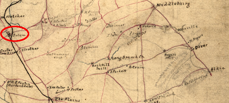
There were once two places called "Salem" in Virginia. Students of the Civil War who trace Stonewall Jackson's incredible march to the Second Battle of Manassas in August, 1862 will see references to his troops passing through Salem. His "foot cavalry" hiked 54 miles in 36 hours, in the summer heat, on the way to the burning of the Union supply depot at Manassas.
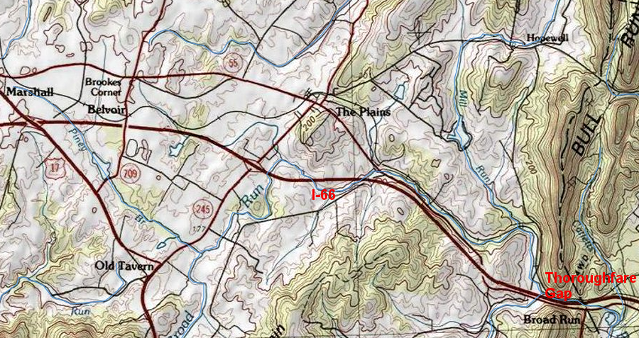
Those Civil War soldiers led by General Jackson did not march through the City of Salem in southwestern Virginia. They walked from the Rappahannock River north to what is today I-66, turned east to go through Thoroughfare Gap, and got between the Federal army under General Pope and Washington DC.
The name of the Fauquier County town that was known in 1862 as "Salem" is now called "Marshall." The name was changed to avoid confusion with the other Salem, near Roanoke. The name "Marshall" honors John Marshall, the Supreme Court Justice who owned Oak Hill nearby. That house is now associated with the Barrel Oak Winery and used for weddings and corporate events. The story of how Marshall got its name has been told more than once over a glass of wine there.
Some Native American names were recycled by the colonists and still remain on the map after 400 years of European occupation, such as Shenandoah, Roanoke, and Quantico. However, DeLorme did not try to include every neighborhood in the Index and provide a 100% complete gazetteer of place names, so don't be surprised to discover your favorite shopping center may not be listed.
In addition, natural features such as Rappahannock River or Lake Drummond are not included in the Index. However, the Index can help you get started in locating some natural features.
Mountain Lake is one of the two natural lakes in Virginia, together with Lake Drummond in the Great Dismal Swamp. (There are only two natural lakes in Virginia. Everything else called a "lake" was created by humans who dammed a stream or river.)
Mountain Lake is listed in the Index of the Virginia Atlas & Gazetteer published by DeLorme, because there is a small resort community with that same name next to the lake itself. Similarly, the community of Mechums River in the Index, and provides a clue about the location of the river itself.
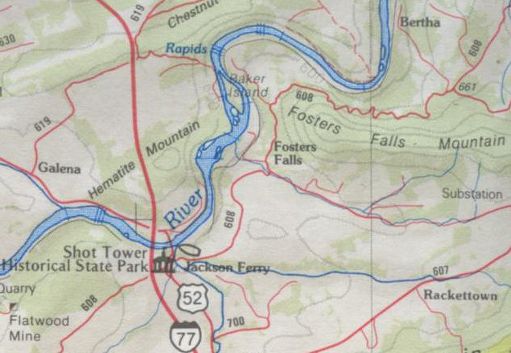
You can find Natural Bridge and Fosters Falls in the Index as well, because populated places adopted the names of those natural features - but can you find Potomac Mills or Kings Dominion?

"Fosters Falls" is a named community, a rapid on the New River downstream (north) of the community, and even a mountain
|

one of the many places called "Five Forks" in Virginia
(map produced before E-911 program required naming all roads)
|

the Fauquier County community called Salem in 1862 is now called Marshall
Source: Library of Congress, Map of Fauquier County, Va.

travelers headed west on I-66 to Shenandoah National Park travel through Thoroughfare Gap in the Bull Run mountains, then pass by Marshall in Fauquier County
Source: ESRI, ArcGIS Online
Class 1: Where Does "Virginia" Begin and End?
Virginia Places
 In the very front of the Virginia Atlas & Gazetteer is the Index. It lists populated places (places where people live), and indicates where you can find that place on a particular map in the atlas. Next to the names of each place are the map number and the grid coordinates on the map.
 Look up Five Forks, Oak Hill, Fairview, Jones Corner, and Mountain View in the Index, and you'll see that Virginians used some place names more than once. There are two places in Virginia called Fredericksburg and two called Blacksburg. There are even two places called Wolf Glade.


