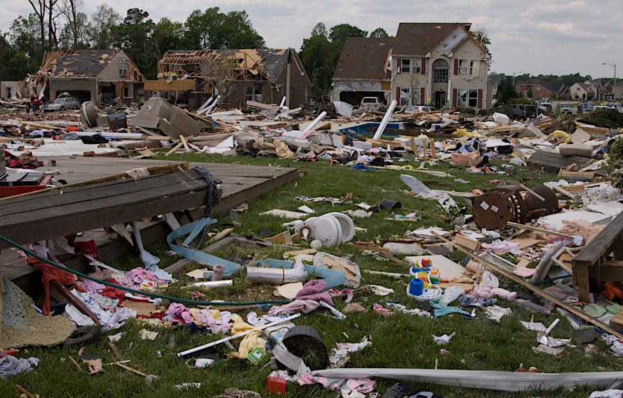
tornadoes knock down trees in the forest and houses in the suburbs
Source: National Archives, Suffolk, VA, 4/30/08 (by Liz Roll/FEMA)

tornadoes knock down trees in the forest and houses in the suburbs
Source: National Archives, Suffolk, VA, 4/30/08 (by Liz Roll/FEMA)
Multiple locations in Virginia have been identified with consistently higher-than-average winds. Those sites are in the mountains and along the coastline. They are the preferred locations for peregrine falcons to nest and for building wind turbines to generate electricity. Tornadoes offer the greatest concentration of windpower energy in Virginia, but their locations can not be predicted and their energy can not be harvested by wind turbines.
Tornadoes are tightly-concentrated, high-energy, violently rotating columns of air. Tornadoes appear and disappear quickly, usually within minutes, and move across the surface of the earth in unpredictable paths. Some are spawned by hurricanes moving west from the Atlantic Ocean or north from the Gulf Coast. Others spin out of strong storms that typically move east across the continent into Virginia.
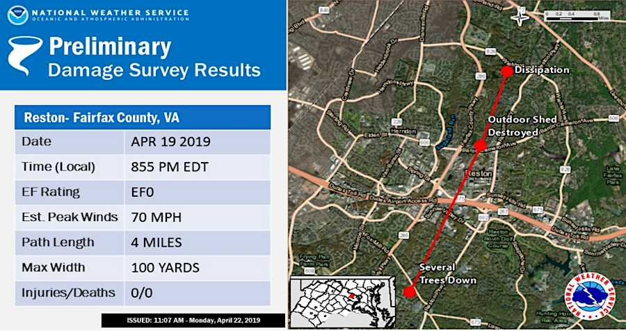
tornadoes are powerful enough to destroy structures and kill people
Source: National Oceanic and Atmospheric Administration (NOAA), April 19 Tornado Paths Virginia
Unlike a hurricane, and despite the graphic depictions in the movie Twister, there is no "eye" inside a tornado. Tornadoes consist of a series of counterclockwise spinning vortices which swirl inside a larger parent circulation. They are too narrow to have a stable and calm center, though wind speeds are lower within the interior of the column of air.
Within the United States, there are on average 1,200 tornadoes per year. To date, the strongest wind speed measured by Doppler radar is 318 miles per hour. Twisters move along the ground at an average of 10-20 miles per hour; they do not stay in one place. An individual location will experience destructive winds for just a brief moment.
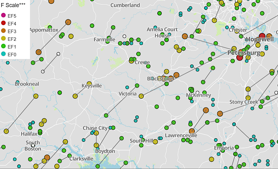
many tornadoes in Virginia move from the southwest to the northeast
Source: News Leader, A history of twisters: Tornadoes in Virginia since 1950
Tornadoes occur in ally physiographic provinces. They have been recorded in the Appalachian mountains and on the Blue Ridge, as well as on the more-open Valley and Ridge, Piedmont and Coastal Plain. Richmond was struck by a tornado in 1816, 1820, 1912, 1936, 1951, 1956 (twice), 1969, 1980, 1984, 1989, 2003, 2004 (twice), 2010 - and five times in 2018.
Significant damage to buildings from a Virginia tornado occurred in 1951, when a tornado stayed on the ground for 15 minutes and a dozen people were injured, but the most expensive damage to date was caused by a 2008 tornado that touched down in Petersburg and Colonial Heights. The deadliest tornado occurred in 1929, when 13 people died in Scott County when a school in Rye Cove was struck.
Between 1999-2018, there was an average of 1,225 tornadoes annually in the United States. Two states in the heart of "Tornado Alley" experienced the most - Texas with an average 155, and Kansas with 96. The risk of a tornadic thunderstorm moves north after April-May as the strong jet stream winds move north.
Between 1991-2010, Virginia experienced 18 tornadoes annually on average. More accurate reporting rather than climate change appears to account for an apparent increase from data showing that the state experienced just 10 tornadoes per year. The strength of the storms does not appear to be increasing:1

Virginia very rarely experiences tornadoes with winds reaching 150 miles per hour
Source: National Weather Service (NWS), NWS Wakefield Tornado Database

the average of just 8 tornadoes per year between 1950-2025 may reflect lower reporting in the past rather than a recent increase in tornadoes due to climate change
Source: National Weather Service (NWS), NWS Wakefield Tornado Database
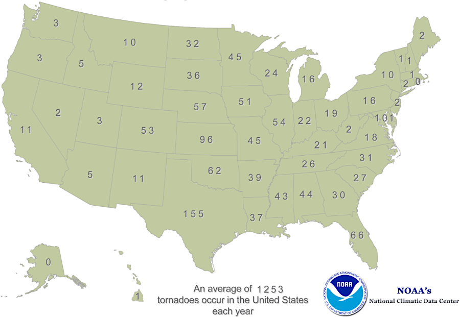
Virginia experiences only 1% of the tornadoes that touch down in the United States each year, on average
Source: National Oceanic and Atmospheric Administration (NOAA), Historical Records and Trends
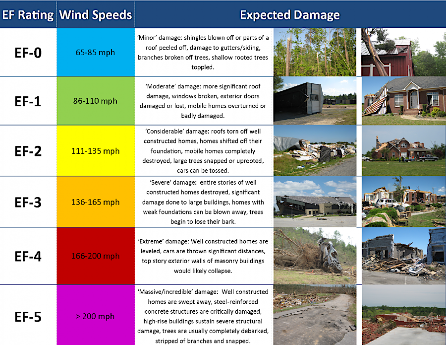
Tornadoes are classified by wind speeds which are correlated to their effects on the ground, particularly on human-built structures. The original Fujita Scale was "enhanced" in 2007 to align wind speeds with property damage more closely.
Only the National Weather Service determines if a wind event was officially a tornado; it assigns the official Enhanced Fujita (EF) Scale rating to each tornado. EF ratings are based on after-the-fact estimates of wind speed based on the visible effects on structures, not on actual measurements of wind speed by scientific instruments or sensors.
Where tornadoes cross open fields, damage is particularly hard to estimate. A 2021 study using Doppler radar measurements suggested that the National Weather Service has underestimated the power of such tornadoes, with ratings 1.2 to 1.5 categories too low compared to comparable storms damaging structures.
Tornadoes form when the moist air bursts into the dry air. Rapid cooling of the moisture releases heat as the air rises. That heat triggers strong storms. With the right combination of westerly air currents high above the ground and more-southerly winds below, twisting air flows can morph into tornadoes.
Tornadoes are common in the Midwest because wind currents carry dry cool air east from the Rocky Mountains towards the Mississippi River, where it encounters moist warm air moving north from the Gulf of Mexico. Where there are sharp boundaries of dry/cool air above warm/moist air, severe thunderstorms and tornadoes can form.
The traditional Tornado Alley, where supercell thunderstorms have been most common, includes parts of Kansas, Nebraska, Iowa, Oklahoma, and northern Texas. The first tornado forecast was made in 1948, after a twister damaged Tinker Air Force Base in Oklahoma on March 20. Five days later, two meteorologists in the Air Force determined that atmospheric conditions were similar and correctly warned that another twister was likely to strike again.
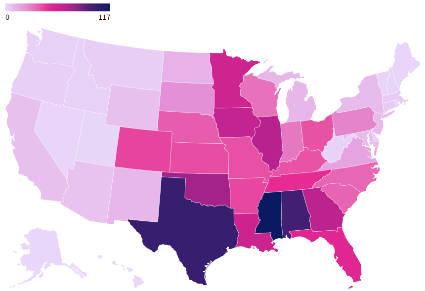
in Dixie Alley, Mississippi had the most tornadoes (117) between 2019-2023
Source: USA Facts, Beyond Tornado Alley: Which states have the most tornadoes?
In 1952, the Air Force's Severe Weather Warning Center initiated "Tornado Alley" project to study how to predict tornadoes. Meteorologists in the National Oceanic and Atmospheric Administration (NOAA) are able to provide severe weather alerts and issue tornado watches/warnings based on the route of a storm, but are not able to predict the specific paths of whatever tornadoes might be created.
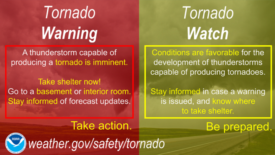
a tornado warning is the most urgent alert issued by the National Weather Service
Source: National Weather Service, Thunderstorms, Tornadoes, and Weather Safety - VA
In Virginia, in contrast to the Midwest, a layer of dry air in the upper atmosphere rarely traps warm, moist air at the surface. The adiabatic lapse rate, the rate of change in air temperature at higher elevations, is typically too weak to spawn twisters.
"Rarely" is a relative term. Every state, including Alaska, has reported tornadoes. Cold air masses can spawn tornadoes so long as the surface temperature is colder than the temperature higher up in the atmosphere. Because the storms need both moisture and warm air plus a sharp boundary between different air masses in order to form, tornadoes have not been reported north of the Arctic Circle or in Antarctica.
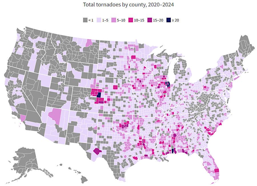
between 2020-2024, tornadoes strick Lee County, Virginia Beach, Faifac County, and multiple places in-between
Source: USA Facts, Where do tornadoes do the most damage?
Perhaps due to the warming climate, tornadoes are becoming more common in the southeastern states. In "Dixie Alley" - eastern Texas, Louisiana, Alabama, and Mississippi - the tornado season occurs later in the year than the Midwest, with more storms in October and November. Since the 1980's the greatest number of tornadoes have formed in Mississippi, Louisiana and Alabama rather than within the traditional Tornado Alley further west in Texas, Oklahoma and Kansas. If the Wizard of Oz was written today, Dorothy might say "Toto, we're not in Mississippi anymore..."
A second factor limiting tornadoes in Virginia is the presence of mountain ridges, including the Blue Ridge. Ridges serve as barriers that limit mixing of air masses. When thunderstorms travel eastward across the mountains, they often run into dry air from the northeast that can be 10-20 degrees cooler. That creates strong storms which produce locally heavy rainfall. However, instead of air masses creating a broad supercell with twisting air currents, the winds quickly wither away:2
On occasion, supercells in storms that form over Alabama and Tennessee can move north along the Appalachians into Virginia with enough energy to spawn tornadoes despite the mountain barriers.
The April 2-3, 1974 Super Outbreak generated tornadoes across the southeastern states. In Washington County, one person in a mobile home was killed. A tornado near Roanoke touched down on the land later developed as Valley View Mall. A repeat today, after development has sprawled outward from the city center, would cause much greater destruction.
The April 2011 Super Outbreak lasted four days and produced 360 tornadoes across 21 states. There were 19 tornadoes in Virginia alone on April 27-28, 2011. Four people were killed at Glade Spring, and tractor-trailers at the Petro Truck Stop on I-81:3
tornadoes knock down trees in the forest and houses in the suburbs
Source: National Weather Service, January 13 2013 EF0 Eagleville Tornado
Tornadoes can kill people as well as destroy property at any location in Virginia. The First Baptist Church in Williamsburg, founded by free and enslaved black people in 1776, was destroyed by a tornado in 1834. A new church was not constructed by the congregation until 1856.4
Between 1950-1994, the 279 tornadoes recorded in Virginia killed 25 people. Though Virginia has only 1% on average of the tornadoes that touch down in the United States each year, it is in the middle of the 50 states for number of tornadoes causing fatalities and the total number of deaths.
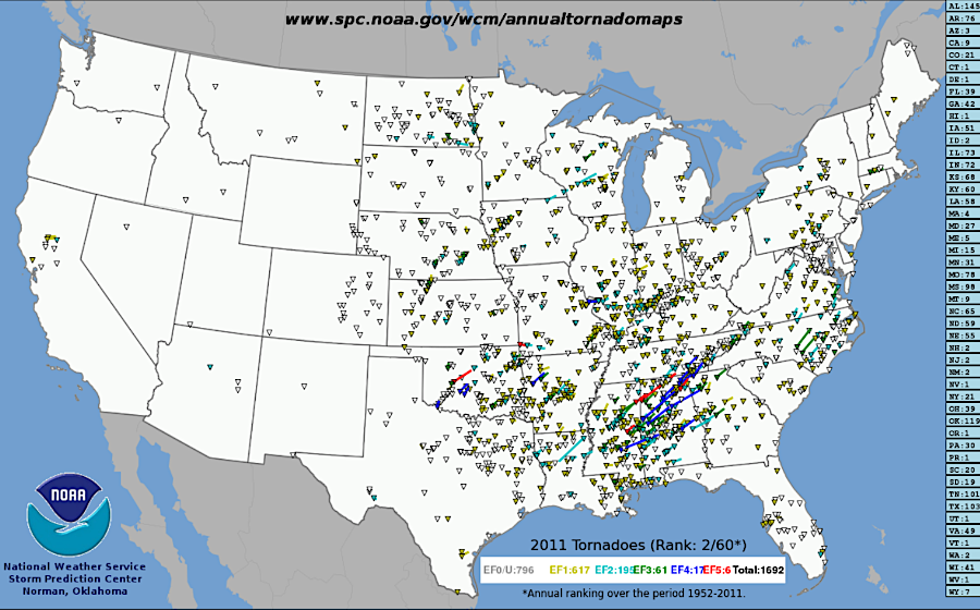
in 2011, there were 49 tornadoes in Virginia
Source: National Oceanic and Atmospheric Administration, U.S. Annual Tornado Maps (1952-2011)
Tornadoes peak in April and again in September, when hurricanes are likely to strike Virginia. Most strike in the afternoon when the sun has heated the atmosphere and instability is greater:5
Less than 20% of the tornadoes in Virginia are rated as EF-2 or higher on the Enhanced Fujita Scale, but the most powerful storms cause roughly 80% of the property damage and injuries and almost 90% of the fatalities. The less-intense EF-0 tornadoes touch down only briefly, with a track on the ground averaging 1.7 miles. The EF-2 tornadoes stay on the ground for an average of five miles, while EF-3 tornadoes touch down for an average of 10 miles. As a result, EF-2 and stronger tornadoes have a greater opportunity to encounter structures as well as more power to demolish buildings.6
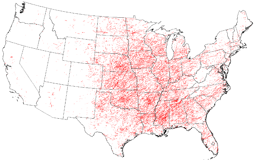
tornado paths between 1950-2019
Source: Storm Prediction Center, National Weather Service, SVRGIS
Though news stories often highlight the highly-visible damage to rural trailer homes, cities are not immune. On July 1, 2021, an EF-1 tornado touched down in Arlington County and stayed on the ground for over four miles. The tornado moved from the Cherrydale neighborhood through Lyon Village, crossed Rosslyn, then left the ground near 16th Street and Constitution Avenue NW in Washington, DC.
Two EF-0 tornadoes touched down on March 31, 2022 in two Fairfax County locations. One was on the ground for just a minute near Cub Run Elementary School in Centreville, leaving a track 30 yards wide and 80 yards long. Another tornado damaged two gas stations along Chain Bridge Road, just northwest of Tysons Corner Center. Debris ended up on the Silver Line Metro track.
On August 6, 1993, 18 tornadoes swept across southern Virginia. A tornado with winds reaching 225 miles per hour blasted downtown Petersburg. It damaged more than half of Old Towne’s buildings and destroyed the eastern freight wing of the South Side Railroad Depot. The tornado then destroyed 47 of the 57 buildings on Pocahontas Island. In one of the quirks of tornado damage, a church was blown away but the Bible on a podium was left undisturbed.
The storm finished crossing the Appomattox River and demolished the Wal-Mart in Colonial Heights, a site previously struck by tornadoes in the 1850s and again in May 1990. In 2008, another F1 tornado touched down near there, stacking cars on top of each other in the Best Buy parking lot.
A total of 259 were injured and four people were killed on that day. No one died in Old Towne, but three died in the Colonial Heights Wal-Mart and one person was crushed to death when a cinderblock building collapsed at a sand and gravel pit company in Prince George County. The tornado caused $50 million in damage, the greatest in Virginia history. As remembered by the National Weather Service:7
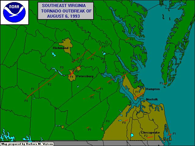
18 tornadoes crossed southern Virginia on August 6, 1993
Source: National Weather Service, Remembering the Tornado Outbreak of August 6, 1993
The economic impact on Petersburg was significant. The wing of the South Side Station was not rebuilt, and empty lots were still present in downtown Petersburg three decades later. The city had been starting to redevelop its downtown and attract small independent businesses, tourists, and residents. The mayor estimated that the economic recovery of Petersburg was delayed 15 years by the storm, because many of the damaged buildings had been listed as National Historic Landmarks and could not be bulldozed:8
No place outside of a cave is "safe" from a tornado. A quick-forming July, 2014 tornado with winds around 100 miles per hour knocked trees onto tents and recreational vehicles at a campground filled with 1,300 people near Cape Charles on the Eastern Shore. Two campers were killed, and 36 others injured.9

between 1950-2020, six tornadoes were documented in Northampton County
Source: National Oceanic and Atmospheric Administration, Storm Events Database
The deadliest tornado to hit Virginia, so far, was in 1929 in Scott County's Rye Cove. The two-story wooden school building with eight rooms and an auditorium was demolished. Of the 150 people at the Rye Cove Consolidated School just as recess ended, 54 were injured. Of the 13 who were killed, 12 were students and one was a teacher. Her body was carried 75 yards away as the building was smashed by the powerful wind.
That same day, another tornado struck a school in Rappahannock County near Woodville. One student was killed and 15 more people were injured. On that day, at least 22 people were killed by 5 separate tornadoes in Virginia.
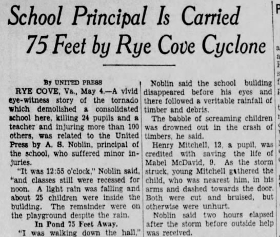
Virginia's most-deadly tornado killed 12 students and one teacher at Rye Cove in 1929
Source: Newspapers.com, The Springfield Press (May 4, 1929)
According to one teacher at Rye Cove, there was no time to seek cover and "the building collapsed with a smash" as soon as the storm hit. The school principal described how the tornado was a complete surprise:10
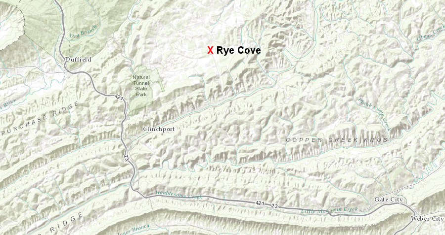
Virginia's most-deadly tornado killed 12 students and one teacher at Rye Cove in 1929
Source: ESRI, ArcGIS Online
One of the rescuers, A. P. Carter, composed a song about what he saw with the lyric:11

the Rye Cove in Scott County after a 1929 tornado
Source: Library of Virginia, Men View the Ruins of Rye Cove School
In addition to a spinning tornado, strong winds may also be dangerous. When the Blue Ridge is at the edge of high pressure systems from the north in January/February, and low-pressure systems are located to the southeast near the warmer ocean, winter winds can flow through the gap at speeds up to 120 miles per hour. That is sufficient to rip the doors off of vehicles, overturn trucks, and even lift people into the air.
On January 24, 2003, five tractor-trailer trucks were flipped onto their sides on Interstate 77 at Fancy Gap. A state trooper who reported to the accident scene claimed he had to hold onto the guardrail to avoid being tossed over the edge of the roadbed that had been carved into the side of the mountain. Another said:12
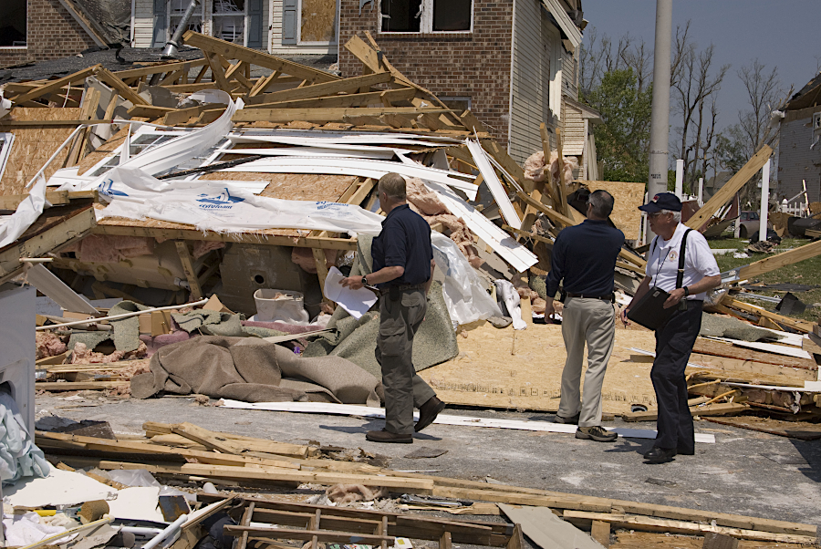
Federal and state officials assessed damage from a 2008 tornado in Suffolk
Source: National Archives, Suffolk, VA, 5/01/08
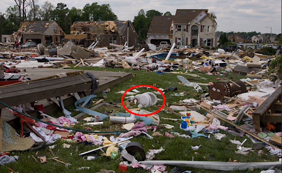
the 2008 EF-3 tornado in Suffolk created a debris field, including a toilet left in the yard
Source: NARA & DVIDS Public Domain Archive, Suffolk, VA, 4/30/08
Any spot in Virginia can experience a powerful storm. As articulated by a meteorologist discussing how tornadoes were becoming a greater threat in Pennsylvania:13
Virginia communities may also be impacted by a "derecho." A derecho (Spanish for "straight") is a series of downbursts at the front of a storm, a straight-line continuous series of windstorms driven by a cold front pressing against warmer air. To be labelled as a derecho, a storm must be 60 miles in width, include 58mph wind gusts, and continue for 400 miles in length.
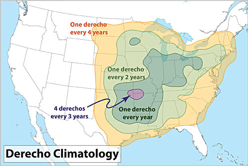
Virginia experiences a derecho once every four years, on average
Source: National Oceanic and Atmospheric Administration (NOAA), About Derechos
A derecho may have helped George Washington and the Comte de Rochambeau defeat General Cornwallis at Yorktown. The British planned to escape the siege on the night of October 16, 1781 by transferring 8,000 troops across the York River to Gloucester, then breaking through the thin line of American forces there and marching north through Gloucester County. Crossing the York River would require 16 flatboats, each making three trips from Yorktown to Gloucester Point before dawn.
During the second crossing, an extraordinary storm that could have been a derecho or "line squall thunderstorm" blocked the boats from crossing the river. Winds were so strong that two boats loaded with soldiers were blown out into the Chesapeake Bay. They were captured by French ships that had blocked the Royal Navy from providing reinforcements or evacuating the British army. Cornwallis abandoned the attempt to escape, and on October 17 asked for terms of surrender from George Washington.14
A derecho with 80 mile per hour winds struck Virginia on June 29, 2012. The storm created havoc for 600 miles as the front moved from the Midwest to the Delmarva Peninsula. In Virginia, 15 people died. Trees falling on power lines caused the third-largest power outage in the state's history, exceeded only by hurricanes Isabel and Irene. The 2012 derecho sped up plans to place distribution lines underground in the most outage prone areas.15
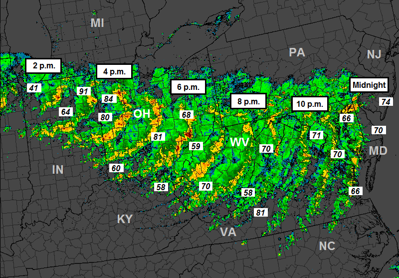
the June 29, 2012 derecho moved steadily from Chicago to Virginia
Source: National Oceanic and Atmospheric Administration (NOAA), The Ohio Valley / Mid-Atlantic Derecho of June 2012
Port City Brewing Company in Alexandria saved its 13,000 gallons of beer by allowing one batch to ferment at higher temperatures. The beer in process was supposed to be fermented at cool temperatures, but the brewery made steam beer (California common) instead of lager and labelled it "Derecho Common." A year later, an anniversary party at the brewery got an added dose of authenticity when there was a brief power outage and the celebration required flashlights.16
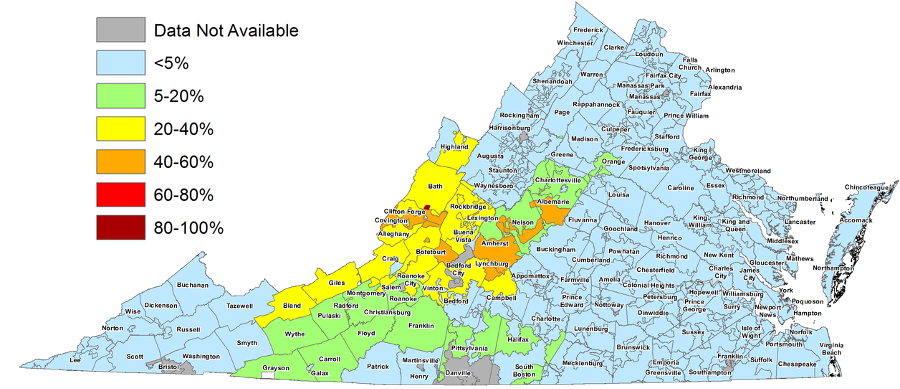
the 2012 derecho knocked over trees and caused widespread power outages for a week after the storm
Source: Virginia Derecho Blog, power outages as of July 5, 2012
In 2016, a rare February tornado touched down in Campbell and Appomattox counties. The strong EF-3 tornado stayed on the ground for 17 minutes and left a swath of destruction for 17 miles; Doppler radar recorded debris 10,000 feet above the ground. Seven people were injured and one was killed.
Five years later in December 2021, a major outbreak of tornadoes killed over 80 people across eight states from Indiana to Georgia. The Appomattox Fire Department responded by donating their 1990 Pierce Fire Engine to the fire department in Samburg-Reelfoot, Tennessee.17
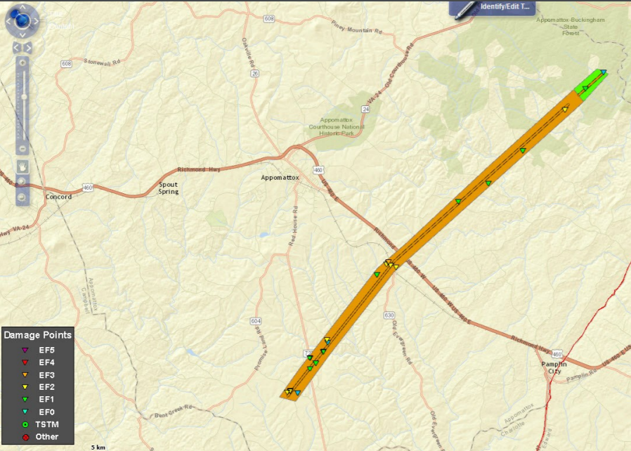
a tornado in February, 2016 crossed through 17 miles in Campbell and Appomattox counties
Source: National Weather Service, Rare February Tornadoes in Mid-Atlantic: Focus on tornadoes in Appomattox and Patrick Counties of Virginia, February 24, 2016 (Figure 6)
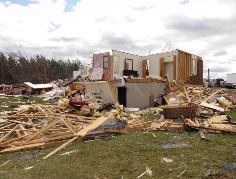
the EF-3 tornado in February, 2016 started its track on the ground near the community of Evergreen in Appomattox County
Source: National Weather Service, Rare February Tornadoes in Mid-Atlantic: Focus on tornadoes in Appomattox and Patrick Counties of Virginia, February 24, 2016 (Figure 6)
The Peter's Mountain Roar in Giles County is a Spring phenomenon almost every year, sounding like "a tremendous thundering roar of giant waves breaking over rocky reefs" and " the roar of a thousand lions."
The noise may be created by a current of wind passing over the mountains, sinking down from the cragged crest of Tuscarora Sandstone to strike the valleys, then rising up again. The starting point of the wind is to the east:18
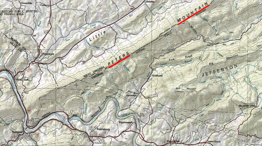
the Peters Mountain Roar at the West Virginia border is caused by winds from the Atlantic Ocean
Source: ESRI, ArcGIS Online
Tourists visiting Virginia as well as residents may experience a tornado. On April 30, 2023, an EF-3 tornado swept through the Great Neck section of Virginia Beach, just west of First Landing State Park. The storm caused $15 million in damage to about 100 homes, but no deaths. The city opened a shelter at Great Neck Recreation Center, but most people affected by the storm were able to find a hotel room.
The storm struck before the peak of the tourist season, so there was excess hotel capacity in the resort area. Heavy rain earlier that day had forced cancellation of the third day of the Something in the Water festival organized by Pharrell Williams, who had grown up in Virginia Beach.19
Source: NOAA Weather Partners, NSSL's Severe Weather Research in the Field
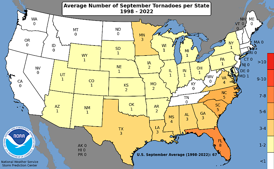
Virginia gets a peak of tornadoes in April and August
Source: National Weather Service (NWS), NWS Wakefield Tornado Database
Source: NOAA SciJinks, What Causes a Tornado?
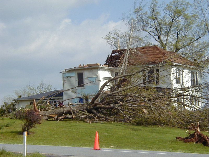
shade trees next to houses can become projectiles and bludgeons in a tornado
Source: Flickr, Bedford County Virginia Tornado Damage April 2002 (by Kipp Teague)
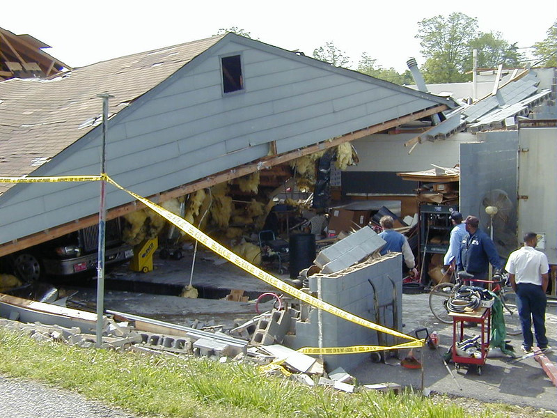
tornado winds lift roofs off structures without hurricane roof clips
Source: Flickr, Bedford County Virginia Tornado Damage April 2002 (by Kipp Teague)
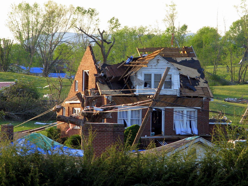
an EF3 tornado struck Grade Spring on April 27, 2011
Source: Brent Moore, 4/27 Tornado Damage - Glade Spring, VA

most tornadoes strike in the Great Plains or near the Gulf Coast
Source: Storm Prediction Center WCM Page, National Weather Service, Tornado Climatology -- All Tornadoes