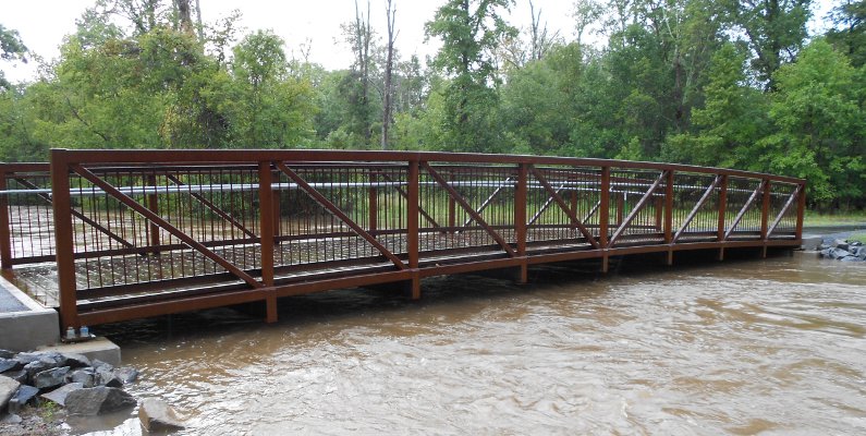
Cub Run in Fairfax County, "bankfull" but not flooding after Tropical Storm Lee in September, 2011
Cub Run in Fairfax County, "bankfull" but not flooding after Tropical Storm Lee in September, 2011
A "100 year flood" is expected once every 100 years on the average, but there is no guarantee of a 100-year gap between the floods. Every year, there is 1% chance of the 100-year flood occurring.
Every year or two, it is normal for a storm to dump rain so fast that it causes minor flooding. When 10-12 inches of rain falls in just a few hours, stormwater flows down into streams faster than the natural channels can carry that amount of water downstream. The excessive volume of water in the stream rises above the channel, pouring over the streambanks and flooding the adjacent floodplain.
The floodwaters on the floodplains move slower than the water in the stream channel. It slows down as it spreads across the wider area, and may be slowed by vegetation. Floodplains are typically flat, as a result of sediments being deposited by slow-moving floodwaters that are outside the normal fast-flowing channels.
Every century, it is normal to experience a particularly strong storm. A storm with a single cell can empty its cloud in an hour. If warm air currents had delayed rainfall, a "cloudburst" can drop more than 3.94 inches per hour. In addition, cells can reform and multiple cells may dump rain in one specific location for several hours.1
"100-year storms" have a 1% chance of occurring each year; they are not guaranteed to occur just once every century. For example, Virginia had two 100-year storms just three years apart, when hurricanes Camille (1969) and Agnes (1972) brought massive amounts of water into the atmosphere over Virginia.
On a bright sunny day when the James River was a dark brown color, people gathered at a house under the old Huguenot Bridge to push giant tree trunks away from a house. The entire first floor had been flooded, and debris had piled up on the upstream side of the house. The trees were floated back into the river, after the flood had crested and before the floodwaters receded. The homeowners used physical labor because it would be weeks before heavy equipment could cross the saturated soil to remove the debris. Pushing the tree trunks back into the James River put wooden battering rams back into the flood, but by that time everything vulnerable along the shoreline had already been destroyed.2
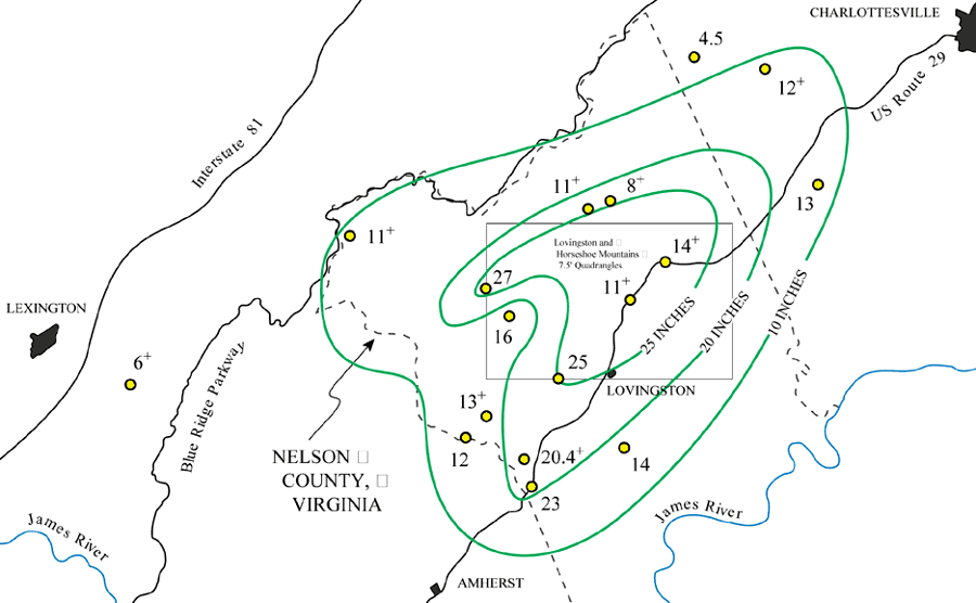
at least 28" of rain fell in Nelson County during one 8-hour period, when Hurricane Camille stalled over the Blue Ridge in 1969
(plus signs indicate that rain gauges overflowed and only minimum rainfall is known)
Source: US Geological Survey, Inventory Of Debris Flows And Floods In The Lovingston And Horseshoe Mountain, Va, 7.5' Quadrangles, From The August 19/20, 1969, Storm In Nelson County, Virginia (Figure 1)
A 1,000 year flood has only a .1% chance of occurring. During Tropical Storm Lee on September 4, 2011, seven inches of rain fell in just 3 hours at Fort Belvoir in Fairfax County. That may have been a 1,000 year flood - but it could occur again at any time. There is a .1% chance of another flood like that every day, and no guarantee that there will be a 1,000 year pause before the next flood of equivalent size.3
Storm surges along the coastline are serious threats. Analysts at insurance companies have to calculate the expected number of claims that will be paid each decade, and define the minimum amount that that the companies should charge for insuring against specific risks.
Virginia Beach is at risk of a storm surge flooding the city during a Category 3 hurricane. The level of flooding in the city would vary, depending upon:
In the maps below, "green" indicates dry land and "blue" indicates water-covered areas. Normally, Back Bay is separated from the Atlantic Ocean by a thin beach and a line of sand dunes.
In a Category 3 hurricane, Back Bay will expand. On the west, all the land between Back Bay and the North Landing River will disappear under water. On the east, almost all of the land separating Bay Bay and the Atlantic Ocean will be flooded.
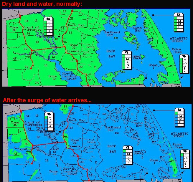
Source: Hampton Roads Emergency Management Committee Hurricane Flooding and Tidal Surge maps
Insurance companies with policies covering damages from hurricane surge impacts on southeastern Virginia Beach can't control the weather. They can only control the "floodproofing." In some areas, engineers could build floodwalls around a building, complex, or a neighborhood that would protect against water that rise 1, 2, maybe even 4 feet.
That would cost vast sums of money. Usually the costs for such projects (such as the widening of the beach by dredging sand offshore and pumping it onshore at the resort portion of Virginia Beach) are spread over a wide number of people, by using government (tax) dollars. Occasionally, a special land use district is defined, and the property owners in that particular district pay a higher-than-normal tax to cover the costs of the higher-than-normal protection. Property owners at Sandbridge funds their beach replenishment through a special tax.
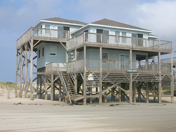
beach cottage on stilts (at Corolla, NC)
Another form of floodproofing is to move structures away from the water. This move can be vertical or horizontal. At Sandbridge (the beachfront community north of False Cape State Park and Back Bay National Wildlife Refuge) the houses are built on stilts. The first floor is 10-14 feet above the ground; the posts in the ground can get wet in a "northeaster" or mild hurricane, but the kitchen and bedrooms stay dry. Residents and those renting a vacation cottage have to walk up and down steps every time they go outside, though they can park their cars in the shade under the house...
Moving the house away from the flood reduces the risk of damage. On the opposite side of Virginia, the entire town of Grundy in Buchanan County was moved to the other side of the Levisa River, after a major flood in 1977 killed three people. The project reduced the threat of future property damage from major floods by moving Grundy both vertically and horizontally out of the flood zone, in addition to creating a levee to control the water.
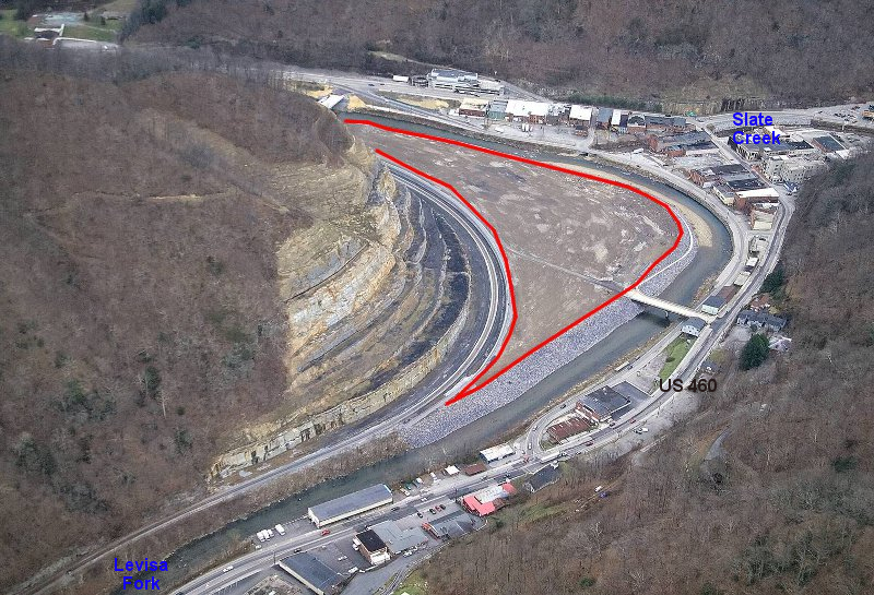
red polygon indicates site for new Grundy Town Center, before commercial strip along US 460 was moved across the Levisa River
Source: US Army Corps of Engineers
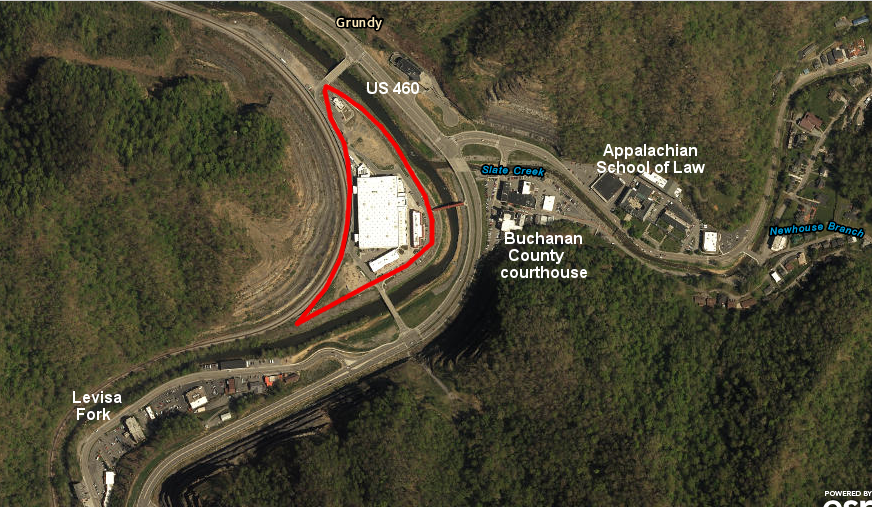
most stores upstream of Slate Creek were eliminated by widening US 460, and retail businesses were concentrated in one building across the Levisa Fork (with the new Wal*Mart in the third story)
Source: ESRI, ArcGIS Online
In the last 50 years, hurricanes coming through Virginia have flooded shoreline communities, but the greatest damage has occurred far inland from Hampton Roads on the Blue Ridge. In 1995, a 500-year storm reshaped Paine Run in Augusta County, Staunton River in Madison County, and Moormans River in Albemarle County.
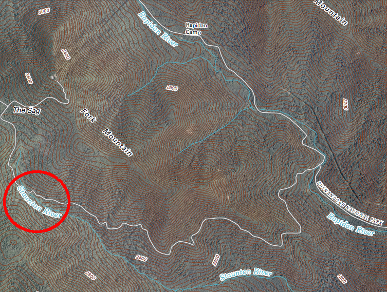
Staunton River in Madison County, south of President Herbert Hoover's getaway at Rapidan Camp
Source: US Geological Survey, Fletcher 7.5x7.5 topographic quad (2010)
(NOTE: a stretch of the Roanoke River between Smith Mountain Lake and Clarksville is also called the Staunton River)
The historic floods in Roanoke, Virginia in 1995 and the impact of Hurricane Camille in 1969 show that rainfall patterns are not steady.
In the last decade, study of such floods are revealing how important they are in shaping the topography of streams in the Blue Ridge. We are discovering that streams are "underfit," meaning that the erosive power of the small streams does not appear to be sufficient for carving such wide valleys and moving the giant boulders in the streambeds. However, once every few centuries, it appears that very-localized storms can drop so much rain in one watershed that one storm can transform hillsides for centuries.
Floods are natural events. Building structures outside of the 100-year floodplain can reduce damage, but some floods are even larger than the 100-year average peak storm.
Debris flows and catastrophic landslides are reshaping the Blue Ridge and the Appalachians, as water works its magic on the landscape. The gradual drip-drip-drip of everyday rainstorms causes little erosion. The gradual erosion from chemical and physical weathering, caused by summer thunderstorms and winter freezing and thawing, will inevitably reduce the Blue Ridge to a flat Piedmont - but each decade or two, somewhere in the Appalachians, a big storm will move a chunk of the mountains downhill towards the Atlantic or the Gulf of Mexico.
The rare (every 500-years or so, on the average) events are literally the earth-movers where we can see mountain-shaping happen overnight. The "singularities" of rare events punctuate the normal pattern of gradual erosion and speed up the process of flattening the mountains...
As described in a Resource Assessment of the June 27 and 28, 1995 Floods:4
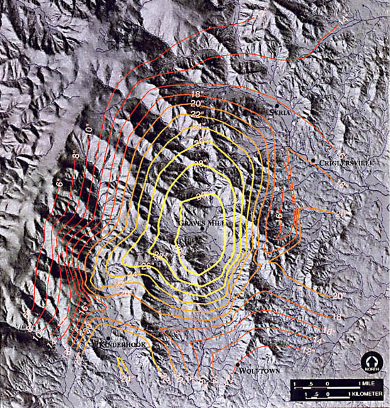
over 30 inches of rain fell in a 1995 storm in Madison County, creating landslides
Source: US Geological Survey, Debris-Flow Hazards In Areas Affected By The June 27, 1995 Storm In Madison County, Virginia (Image 1)
The Blue Ridge has not been flattened yet, and not only because the billion-year old granitic core (and 600-million year old lava coating) resists erosion. The mountains are still being uplifted, perhaps by whatever geologic force that is moving the eastern part of the continent towards the west at the speed your fingernails grow, and the particles of quartz are still eroding and washing downstream.
Erosion may not win every battle. Virginia's mountains may have eroded to a lower height at the end of one human lifetime - but topographic relief may increase, if an adjacent valley has eroded even faster.
1. "What is a cloudburst?," Stormwater Solutions, January 24, 2025, https://www.stormwater.com/what-is-series/article/55263420/what-is-a-cloudburst (last checked January 29, 2025)
2. personal experience
3. "National Weather Service: Ft. Belvoir rain was more than 1 in 1,000 year event, 'off the charts'," Washington Post, September 12, 2011, http://www.washingtonpost.com/blogs/capital-weather-gang/post/national-weather-service-ft-belvoir-rain-was-1-in-1000-year-event/2011/09/12/gIQA7PtRNK_blog.html (last checked September 18, 2011)
4. Karish, John, Blount, Tom, Krumenaker, Bob, "Introduction," Resource Assessment of the June 27 and 28, 1995 Floods, Natural Resources Report NPS/SHEN/NRR-97001, National Park Service (Shenandoah National Park), April 1997, www.nps.gov/shen/ps/nr/mi/fr95/fr95.htm; "Floods and Droughts in Roanoke, Virginia," http://va.water.usgs.gov/floods_and_droughts_in_roanoke.pdf (last checked September 15, 2002)
5. Karish, John, Blount, Tom, Krumenaker, Bob, "Introduction," Resource Assessment of the June 27 and 28, 1995 Floods, Natural Resources Report NPS/SHEN/NRR-97001, National Park Service (Shenandoah National Park), April 1997, www.nps.gov/shen/ps/nr/mi/fr95/fr95.htm (last checked September 15, 2002)